Vai al contenuto

Orsomarso

    Orsomarso, situato tra le maestose montagne della Calabria meridionale, in Provincia di Cosenza, è un gioiello nascosto che incanta i visitatori con la sua bellezza naturale e il fascino storico.
    Abbarbicato sulle pendici del Parco Nazionale del Pollino, offre un’esperienza indimenticabile per gli amanti della natura e gli appassionati di storia.
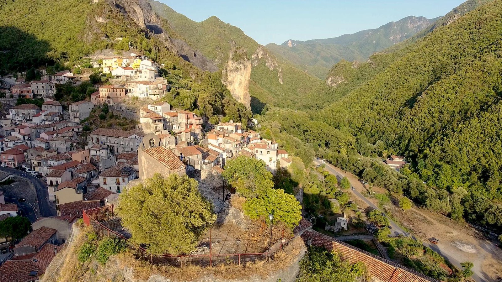
    Il suo cuore è l’affascinante centro storico, un labirinto di stretti vicoli lastricati e antiche case in pietra che raccontano storie di secoli passati. Qui, i visitatori possono passeggiare tra i caratteristici edifici medievali, ammirare le chiese secolari e immergersi nell’autentica atmosfera del sud Italia. Bellissima da visitare è la Chiesa di San Salvatore, imponente nella struttura, di cui si scopre tutta la bellezza guardandola da Piazza Moro. La chiesa, a navata unica, presenta copertura a doppio spiovente e doppio ingresso. All’interno il presbiterio è posto in cima ad una pregevole scalinata in pietra locale. Il
    campanile, uno dei monumenti più belli di Orsomarso, di chiara fattezza medievale, si presenta quale sovrapposizione di numerose forme geometriche: quadrato alla base, ottagonale al primo livello, cilindrico al vano campane e semisferico in cima.
    Interessante è anche il Palazzo Baronale, risalente ad epoca medievale, un tempo sede di un certo Stefano, insignito del titolo di barone di Ursumartio. Questi appose il proprio signum manus in un processo che si celebrò a Scalea, nel luglio del 1152, in merito ad una controversia tra l’abate dell’Abbazia Benedettina di S. Maria della Matina, nei pressi della cittadina di San Marco Argentano e il prete Pietro da Mercurio, a causa della proprietà di una vigna posta in località Charitus, oggi identificata con località “Garritu” di Orsomarso.
    Gli amanti della natura troveranno un paradiso incontaminato nelle vicinanze. Le maestose cime del Parco Nazionale del Pollino offrono una vasta rete di sentieri escursionistici che conducono a panorami mozzafiato, cascate cristalline e ricca fauna selvatica. Gli escursionisti più avventurosi possono intraprendere sfide come l’ascensione al Monte Pollino, la cima più alta della catena montuosa dell’Appennino meridionale. Per chi cerca relax e tranquillità, Orsomarso offre anche la possibilità di rilassarsi sulle sue splendide spiagge sabbiose lungo la costa tirrenica, raggiungibili con un breve tragitto in auto. Qui, i visitatori possono prendere il sole, fare un tuffo nelle acque cristalline del Mar Tirreno e godersi le viste mozzafiato delle scogliere costiere.
    Da mangiare sono le animelle, carne di pecora che è possibile assaporare in diverse salse e ricette tutte tipiche di queste terre.

    PUNTI D’INTERESSE

    Monumento ai Caduti
    La scultura situata al centro dello spazio riqualificato di Piazza A. Moro, realizzata dall’Amministrazione Comunale durante gli anni 1987-1988, rappresenta il mondo, una sfera sezionata in cinque elementi ognuno di essi un continente, la divisione dei popoli causata dalle guerre che coinvolsero tutte le nazioni. Nell’anno 2016, l’Amministrazione Comunale ha riqualificato ulteriormente lo spazio, arricchendo la scultura con tesserine di mosaico, a cura dell’artista Fulvio Longo e realizzando un’area giochi dedicata ai bambini con disturbi pervasivi dello sviluppo. Alle spalle del monumento, un arco caratterizzato dal lento defluire dell’acqua, simbolo di continuazione della vita, a ricordare il sacrificio di chi è morto per difendere la propria terra.

    The sculpture in the center of the redeveloped area of Piazza A. Moro, made by the Municipality during the years 1987-1988, is the world, a sectioned sphere in five elements, each representing a continent, the division of the people caused by wars that involved all nations. In 2016, the town council further reclassified the space, enriching the sculpture with mosaic tiles, made by the artist Fulvio Longo and creating a play area for children with pervasive developmental disorders. Behind the monument, an arch characterized by the slow flow of water, a symbol of continuing life, to

    Скульптура, находящаяся в центре преобразованного пространства площади Пиацца А.Моро, реализованная муниципальным управлением в 1987-1988 годы, представляет собою мир, шар, разделенный на пять частей, каждая из которых является континентом, разделение людей, вызванное войнами, вовлекшими все народы. В 2016 году муниципальное управление дополнительно преобразовало пространство, украсив скульптуру мозаикой при содействии художника Фульвио Лонго и создав игровую площадку для детей с глубокими нарушениями в развитии. Позади памятника дуга, характеризующаяся медленным потоком воды, символ продолжения жизни, как память о жертвах, погибших при защите своей земли.

    Chiesa del SS. Salvatore
    Imponente nella struttura, si scopre tutta la sua bellezza guardandola da piazza Moro o dal sottostante letto del Porta la Terra. La chiesa, a navata unica, presenta copertura a doppio spiovente e doppio ingresso. All’interno il presbiterio è posto in cima ad una pregevole scalinata in pietra locale. Il campanile, uno dei monumenti più belli di Orsomarso, di chiara fattezza medievale, si presenta quale sovrapposizione di numerose forme geometriche: quadrato alla base, ottagonale al primo livello, cilindrico al vano campane e semisferico in cima. Qui l’Eparchia Monastica del Mercurion ha lasciato una delle sue testimonianze artistiche più belle: un portale lapideo romanico dell’XI secolo. Frammenti sono visibili sulla porta d’ingresso della sacrestia: un’elegante colonnina tortile e un capitello decorato con foglie di edera a sbalzo. Interessante è la presenza, sotto il pavimento, di ambienti naturali, simili a grotte, osservabili in foto d’epoca. È noto che le chiese del Mercurion sono tutte nate nei pressi di grotte, dove i monaci vivevano da eremiti. Intorno a queste grotte potrebbe essersi sviluppato il primo nucleo costruttivo, su cui oggi sorge la chiesa.

    Impressive in its structure, it reveals its entire beauty, looking at it from Piazza Moro or from underneath the Porta la Terra. The church has a single nave, has a gabled roof and two entrances. Inside the presbytery is placed on top of a precious local stone staircase. The bell tower, one of the most beautiful monuments of Orsomarso, clearly of medieval features, is a point of overlap of several geometric shapes: square at the base, octagonal at the first level, cylindrical bell compartments and domed on top. Here the eparchy of the Monastic Mercurion has left one of its most beautiful artistic treasures: a Romanesque stone portal of the eleventh century. Fragments are visible on the front door of the sacristy: an elegant tortile column and a capital decorated with cantilever ivy leaves. Interesting is the presence, under the floor, of natural environments like caves, observable in old photographs. It is well known that the Mercurion churches are all born near caves, where monks lived as hermits. Around these caves the first constructions may have developed, on which now stands the church.

    Впечатляющее сооружение открывается во всей своей красе с площади Моро или находящегося ниже основания ворот Порта ла Терра. Церковь с единственным нефом, двускатной крышей и двойным входом, пресбитерий стоит наверху парадной лестницы из местного камня. Колокольня – один из самых красивых памятников Орсомарсо, чисто средневековое сооружение предстает как наложение нескольких геометрических форм: квадратное основание, восьмиугольный первый уровень, цилиндрический колокольный проем и куполообразная верняя часть. Здесь монашеская епархия Меркурион оставила один из самых красивых художественных сокровищ, романский каменный портал одиннадцатого века. Фрагменты видны на двери ризницы: элегантная крученая колонна и капитель, украшенная выступающими листьями плюща. Интересным является наличие под полом естественных пространств похожих на пещеры, наблюдаемые на старых фотографиях. Известно, что все церкви Меркурион были построены близ пещер, где монахи жили как отшельники. Вокруг этих пещер, возможно, возникла первая постройка, на которой сейчас стоит церковь.

    Cenni Storici
    Orsomarso, bagnata dalle limpide acque dell’Argentino, posta a 120 mt. S.l.m., ha origini di epoca greco-romana come fortezza militare (Kastron) posta a difesa di una delle più importanti vie di comunicazione tra mar Ionio e mar Tirreno. Le sue origini rimandano all’antica colonia achea “Abystron”. L’origine del nome Orsomarso risalirebbe ad epoca bizantina, per l’esistenza di un funzionario imperiale di nome Oursos Marsos. Nella prima metà dell’XI secolo, si costituiva l’abitato di Orsomarso. Esso assunse grande rinomanza in epoca medievale, per aver ospitato molti monaci italo-greci, a cui si deve la nascita e l’affermazione di una famosa eparchia monastica. Il comune rientra nel perimetro del Parco Nazionale del Pollino e dà il nome alla catena montuosa dell’Orsomarso. Il complesso montuoso, che con la sua cima più elevata (il Cozzo del Pellegrino, mt. 1987 s.l.m.) sfiora i 2000 metri, è stato accostato al Massiccio del Pollino per alcune analogie che ne attestano l’unicità rispetto a montagne vicine. Tra queste, la più evidente è costituita dall’esistenza del Pino Loricato che, con la sua esclusiva presenza, caratterizza il Parco di cui fa parte. Il comune è sede della Riserva Naturale Orientata Valle del fiume Argentino e costituisce il punto di partenza ideale per molti itinerari escursionistici, con aree naturali adatte al picnic. Tra questi si segnalano l’affascinante trekking lungo le gole del fiume Argentino e le emozionanti discese in canoa e del rafting lungo le rapide del vicino fiume Lao. All’imbocco della valle, l’Armolungo, una falesia tra le più conosciute della regione.

    Orsomarso, washed by the clear waters of the Argentino, located 120 meters above sea level, has its origins from Greek-Roman times, as a military fortress (Kastron) positioned to defend one of the most important lines of communication between the Ionian Sea and the Tyrrhenian Sea. Its origins refer to the ancient Achaean colony “Abystron”. The origin of the name dates back to the Byzantine era, Orsomarso, for the existence of an imperial officer named Oursos Marsos. In the first half of the eleventh century the town of Orsomarso was founded. It became important in the Middle Ages, having hosted many Italian-Greek monks, who were responsible for the birth and the affirmation of a famous monastic eparchy. The town is part of the perimeter of the Pollino National Park and gives its name to the Orsomarso mountain range. The mountain range, with its highest peak (the Cozzo del Pellegrino, 1987 meters a.s.l.), has been accosted to the Pollino massif for some analogies that attest to its uniqueness compared to nearby mountains. Amongst these, the most obvious is the existence of the Loricato pine tree, which, with its unique presence, characterizes the Pollino National Park. The town is the seat of the Natural Reserve of the Argentino river valley, and is the ideal starting point for many hiking trails and natural areas suitable for picnics. Noteworthy are the fascinating trekking trails along the gorges of the river Argentino or the thrill of canoeing or rafting down the rapids of the nearby river Lao. The Armolungo lies at the entrance of the valley, a cliff amongst the best known in the region.

    Орсомарсо омывается чистыми водами Арджентино и расположен на высоте 120 м над уровнем моря. Город имеет греко-римское происхождение как военная крепость (Кастрон), поставленная на защиту одной из самых важных линий сообщения между Ионическим и Тирренским морем. Его истоки относятся к древней ахейской колонии «Абистрон». Происхождение названия Орсомарсо восходит к византийской эпохе и связано с жившим тогда имперским чиновником по имени Оурсос Марсос. В первой половине XI века был построен город Орсомарсо. Он получил широкую известность в средние века из-за приема многих итало-греческих монахов, которым обязана своим возникновением и утверждением известная монашеская епархия. Коммуна входит в периметр национального парка Поллино и дает свое название горной цепи Орсомарсо. Горный хребет с самой высокой точкой Коццо-дель-Пеллегрино 1987 м над уровнем моря сопоставим с массивом Поллино по некоторым аналогиям, свидетельствующим об его уникальности в сравнении с близлежащими горами. Среди них наиболее заметная определяется произрастанием сосны Гельдрейха, которая своим уникальным присутствием характеризует парк, частью которого она является. Коммуна является местонахождением природного заповедника в долине реки Арджентино и идеальной отправной точкой для многих туристических маршрутов с природными зонами, пригодными для пикников. К ним относятся увлекательный треккинг по ущельям реки Арджентино, захватывающие спуски на байдарках и рафтинг по порогам близлежащей реки Лао. В устье долины возвышается Армолунго, одна из самых известных скал в регионе.

    Chiesa di S. Leonardo
    A navata unica, già parte integrante del cenobio italo-greco del X secolo, ai cui resti si addossa con il suo lato destro, la chiesetta presenta un’interessante anomalia nel suo sviluppo. A metà circa dei suoi lati lunghi tronca la sua estensione lineare, cambiando orientamento e determinando un diverso sviluppo dei muri perimetrali. È il risultato dell’ampliamento della primordiale struttura bizantina operato nel sec. XVII, la quale inglobava l’area tuttora visibile dei “subsellia”, sedili in muratura costruiti intorno alle pareti, sui quali prendevano posto i monaci durante la preghiera e le celebrazioni liturgiche. La facciata, rivolta ad Ovest, presenta sul portone di ingresso una piccola nicchia, in cui sono distinguibili le tracce di un affresco raffigurante una Madonna con Bambino. L’area più recente è contraddistinta da altari in pietra e malta, sormontati da affreschi del XVII secolo. Il peso del tempo e la forza distruttrice delle intemperie ne hanno messo a rischio la sopravvivenza. Uno di questi affreschi è ancora visibile e raffigura la Deposizione dalla Croce, una scena di grande pathos in cui il Cristo morto è contornato da Giuseppe di Arimatea, da San Giovanni, dalla Madre e da Maria di Magdala. Per un destino simile alla chiesetta di Santa Maria di Mercuri, l’abside, caratteristica e vanto del luogo sacro, è stata ridotta a semplice nicchia per ospitarvi la statua di San Leonardo. Tra la parete di sinistra e quella absidale compaiono due affreschi riproducenti un non identificato santo abate o vescovo e San Fantino Juniore, igumeno e capo spirituale dell’eparchia monastica del Mercurion del X secolo con iscrizione A. D. CCCC XI (1441). L’attuale intitolazione della chiesa si volle per venerare San Leonardo di Noblat, nobile merovingio vissuto in Gallia tra V e VI secolo, il cui culto fu importato nell’Italia meridionale dai Normanni.

    A single nave, already an integral part of the Italo-greek monastery of the tenth century, the remains of which are on the right flank, the church has an interesting anomaly in its development. About halfway along its long sides it truncates its linear extension, changing direction and determining a different development of the perimeter walls. It is the result of the enlargement of the primordial Byzantine structure executed in the 17th century, which encompassed the still visible area of “subsellia”, masonry benches built around the walls, on which the monks took place during prayer and liturgical celebrations. The facade, facing west, presents on the front door a little niche, where the traces of a fresco depicting the Madonna and Child are distinguishable. The more recent area is marked by stone altars and mortar, topped by the seventeenth-century frescoes. The weight of time and the destructive force of the weather have put its survival at risk. One of these frescoes is still visible and depicts the Deposition from the Cross, a great pathos scene where the dead Christ is surrounded by Joseph of Arimathea, Saint John, the Mother and Mary of Magdala. Following a similar fate to the church of Santa Maria Mercuri, the apse, characteristic of the sacred place, was reduced to simple niche to house the statue of San Leonardo. Between the left wall and the apse there are two frescoes depicting an unidentified holy abbot or bishop and San Fantino Juniore, abbot and spiritual leader of the monastic eparchy Mercurion dating back to the tenth century with an inscription A. D. CCCC XI (1441). The current name of the church was given to honor Saint Leonard of Noblat, noble Merovingian who lived in Gaul between the fifth and sixth century, whose cult was imported by the Normans in southern

    Единственный неф уже стал неотъемлемой частью итало-греческого монастыря X века, к развалинам которого примыкает эта церквушка своей правой стороной. Она имеет интересную аномалию в своем развитии. Примерно на половине ее длинных сторон прекращается линейное расширение, меняя направление и определяя иное расширение стен по периметру. Это является результатом расширения первоначальной византийской конструкции, сооруженной в XVII веке, которая охватывала до сих пор сохранившуюся зону «субселлиум», каменные скамейки, построенные вокруг стен, на которых усаживались монахи во время молитвы и богослужений. Фасад, обращенный на запад, с небольшой нишей на входных воротах с различимыми следами фрески с изображением Мадонны с Младенцем. Новейшая зона отличается алтарями из камня с раствором и фресками XVII века. Груз времени и разрушительная сила непогоды поставили под угрозу ее выживание. Одна из этих фресок, еще видимая и изображающая снятие с креста, большая пафосная сцена, где мертвый Христос находится в окружении Иосифа Аримафейского, Св. Иоанна, Матери и Марии Магдалины. Из-за судьбы похожей на церковь Санта-Мария-Меркури апсида, характерная и являющаяся предметом гордости для священного места, была сокращена до простой ниши со статуей Св. Леонарда. Между левой стеной и стеной апсиды привлекают внимание две фрески: одна, изображающая неопознанного святого аббата или епископа, другая – Св. Фантина младшего, игумена и духовного наставника монашеской епархии Меркурион X века с надписью А. D. СССС XI (1441). Нынешнее название церкви в честь Святого Леонарда Ноблатского, благородного члена династии Меровингов, жившего в Галлии в V – VI веках, культ которого был ввезен на юг Италии норманнами.

    Chiesa di Cosma e Damiano
    La piccola, ma graziosa cappella dei SS. Cosma e Damiano è situata all’estremo lembo abitato di via Santa Croce, a ridosso dello sperone roccioso denominato Armo Licani. Rupestre, con una splendida veduta sulla valle del fiume Argentino, presenta una pianta inusuale. Il suo corpus principale è costituito da due ambienti contigui separati da un ampio arco a tutto sesto e posizionati sulla direttrice Est-Ovest, compatibile con l’orientamento a levante di quella che si pensa fosse un’abside, di cui, però, allo stato attuale, non si trova traccia. Il muro di fondo, infatti, appare senza alcuna cavità e senza alcun altare. In compenso, sulla parete campeggia un apprezzabile affresco del XVIII secolo. Presenta due vani finestrati, che confluiscono lateralmente sui due ambienti principali. Adibiti attualmente a sacrestia e a cappellina per ospitare le statue più recenti dei santi martiri Cosma e Damiano, questi ambienti danno l’idea di aver fatto parte, un tempo, di un complesso monastico rupestre, che doveva inglobare anche le piccole case vicine, attualmente adibite a civili abitazioni

    The small but charming chapel of SS. Cosma and Damiano is situated in the more remote inhabited strip of Via Santa Croce, close to the rocky outcrop called Armo Licani. A rock with a splendid view of the valley of the Argentino river and an unusual layout. Its main body is made up of two adjoining rooms separated by a large arch and located on the east-west axis, consistent with the eastward orientation of what we think was an apse, of which, however, there is currently no trace. The back wall, in fact, appears without any cavities and no altar. On the other hand, on the wall stands a valuable eighteenth-century fresco. It has two rooms with windows that flow laterally into the two main rooms. Currently used as a sacristy and chapel to accommodate the newer statues of the holy martyrs Cosma and Damiano, this environment gives the idea that it was once part of a cave monastery complex, which also had to incorporate the small neighboring houses which now serve as civilian homes.

    Небольшая, но очаровательная часовня Св. Космы и Дамиана находится на самом краю Виа Санта Кроче под скалистым выступом, называемым Армо Ликани. Стоящая на скалах с великолепным видом на долину реки Арджентино, она имеет необычный план. Ее главный корпус состоит из двух смежных пространств, разделенных большой полукруглой аркой и расположенных в направлении восток-запад, совместим с ориентацией на восток той, которая являлась, как полагают, апсидой, от которой однако в теперешнем состоянии не осталось никаких следов. Задняя стена, на самом деле, предстает без каких-либо полостей и без алтаря, зато на ней вырисовывается ценная фреска XVIII века. Церковь представляет собой два проема с окнами, которые соединяются сторонами в два основных пространства, используемые в настоящее время в качестве ризницы и часовни. В них установлены последние статуи святых мучеников Космы и Дамиана. Эти пространства наводят на мысль, что когда-то они являлись частью монастырского комплекса, стоящего в скалах, который должен был включать также небольшие соседние домики, в настоящее время служащие гражданским жильем.

    Chiesa di S. Giovanni Battista
    La chiesa è addossata al campanile, che un tempo era una torre urbica, attraverso la quale passava la porta di accesso al primo borgo medievale. A vederla dal fiume Argentino svetta sulle case che la circondano, manifestando tutta la specificità di chiesa rupestre. L’attuale impianto barocco della chiesa non ingloba nulla della prima costruzione in stile romanico, anzi si sovrappone ad essa, evitando che alcuna parete del primo combaci con la seconda. La chiesetta originaria sorgeva nella piazza ai piedi del castello, su cui si affacciavano le prime abitazioni, nate negli spazi vuoti tra i monasteri, che erano comparsi intorno alla rocca tra il IX e il X secolo. Di questo primo impianto sopravvive la parete di destra, che abbondava di monofore e di affreschi. Entrando nell’attuale sagrestia se ne ammirano due di rara bellezza. Il primo ha le fattezze di una Madonna dai capelli biondi e lunghi, assisa in trono e contornata da due angeli reggicortina, secondo gli schemi classici della Basilissa (Madonna Regina). Tuttavia, la presenza nella mano sinistra di un vaso dalla forma allungata, simile ad una pisside, induce a pensare che si tratti della raffigurazione di Santa Sofia, che conserva nel vaso la sophia, la sapienza. Sulla medesima parete si trovano altri due affreschi: la raffigurazione della Madonna del Soccorso, dai tratti somatici vagamente orientali, come gli occhi a mandorla, e quella di un Santo martire, racchiuso in una larga fascia rosso scura, il cui nome, in caratteri bizantini tardi, è talmente danneggiato da comprometterne la lettura. Sulla volta a crociera e sulle pareti del presbiterio si ammirano affreschi di buona fattura eseguiti intorno alla metà del XVII secolo dal pittore orsomarsese, Giovan Battista Colimodio. Notevoli anche le tele della stessa epoca raffiguranti la Sacra Famiglia, la visita di Giovanni ed Elisabetta al piccolo Gesù e Maria, Santa Lucia, Sant’Agata e Gesù in trono.

    Palazzo Baronale
    Il palazzo baronale di Orsomarso, che fa da proscenio all’antistante Piazza Municipio, risale ad epoca medievale ed è stato sede di un certo Stefano, insignito del titolo di barone di Ursumartio. Questi appose il proprio signum manus in un processo che si celebrò a Scalea, nel luglio del 1152, in merito ad una controversia tra l’abate dell’Abbazia Benedettina di S. Maria della Matina, nei pressi della cittadina di San Marco Argentano e il prete Pietro da Mercurio, a causa della proprietà di una vigna posta in località Charitus, oggi identificata con località “Garritu” di Orsomarso. Di notevole interesse l’imponente portale bugnato in pietra locale, attraverso il quale si accede al cortile e, da qui, alla stradina che porta alla Torre dell’Orologio. Fino agli anni ’60 sul lato destro della facciata del palazzo, al di sopra del tetto, svettava un incantevole loggiato rettangolare composto da ben cinque finestroni ad arco a tutto sesto sui lati lunghi e tre su quelli corti.

    The baronial palace of Orsomarso, which acts as a proscenium directly opposite the Town Hall Square, dates back to medieval times and has been home to Stefano, who was awarded the title of Baron Ursumartio. He apposed his signum manus in a process that was celebrated in Scalea, in July 1152, concerning a dispute between the abbot of the Benedictine Abbey of S. Maria della Matina, near the town of San Marco Argentano and the priest Peter of Mercury, because of the properties of a vineyard located in the locality Charitus, now identified with the locality “Garritu” in Orsomarso. Of great interest is the imposing ashlar portal in local stone, through which you access the courtyard and, from here, the road leading to the Clock Tower. Until the 60s on the right side of the facade, above the roof, towered a lovely rectangular porch consisting of five windows with round arches on the long side and three on the short side.

    Баронский дворец в Орсомарсо как авансцена перед муниципальной площадью восходит к средневековой эпохе и являлся домом некоего Стефано, удостоенного звания барона Урсумартио. Он приложил собственный отпечаток руки (сигнум манус) в процессе, который совершался в Скалее в июле 1152 года в отношении спора между настоятелем из бенедиктинского аббатства Санта-Мария-делла-Матина недалеко от городка Сан-Марко-Арджентано и священником Пьетро Меркурио из-за свойств виноградника, расположенного в населенном пункте Каритус, в настоящее время обозначенном как «Гарриту» в Орсомарсо. Большой интерес вызывает внушительный портал, рустованный местным камнем, через который лежит вход во двор, а оттуда на дорожку, ведущую к Башне с часами. До 60-х годов в правой стороне фасада здания над крышей возвышалась очаровательная прямоугольная лоджия, состоящая из пяти больших полукруглых арочных окон по длинным сторонам и трех по коротким сторонам.

    Torre dell’Orologio
    All’epoca dell’Eparchia mercuriense un monastero sormontava la rocca dove oggi troneggia la Torre dell’Orologio di Orsomarso. Il monastero, che ricorda le Meteore, è abbarbicato sulla roccia più alta e imponente. Una volta era una fortificazione longobarda, ma le sue origini si perdono nella notte dei tempi. Fu roccaforte romana o addirittura greca e rivestiva un ruolo di vedetta, oltre che di difesa presso la confluenza dei fiumi Argentino e Porta la Terra. A seguito della riconquista bizantina della Calabria settentrionale (885 d.C.) la roccaforte longobarda ospitò una comunità di monaci italo-greci, che costituirono il cenobio denominato di Castello o del Castellano, citato in alcuni testi agiografici. Fu intorno a questo monastero che si sviluppò il primo nucleo abitativo di Orsomarso (sec. XI d.C.). Sulle strette e ripide scale che portano alla sommità della rocca compare, addossato alla roccia, un robusto muro di pietra e malta che, un tempo, costituiva la parete interna di una sala del monastero. Completamente esposta alle intemperie, essa vede sfumare ogni giorno i suoi antichi affreschi, che mille anni fa erano motivo di vanto e facevano di quell’ambiente il luogo più bello e più ambito dell’intero complesso monasteriale. Continuando a salire si ha modo di osservare alcune monofore, che se da un lato fanno pensare a delle feritoie per la difesa militare, dall’altro, per la somiglianza con le finestrelle monoforate delle chiese di San Leonardo, Santa Maria di Mercuri e della parrocchiale di San Giovanni Battista, riconducono ad un modello architettonico bizantino frequentissimo nelle costruzioni sacre del territorio. Tra tutti i luoghi del Mercurion, questo è quello che meglio conserva l’aspetto di difesa e lascia intravedere una vocazione per la contemplazione.

    At the time of the Mercurion eparchy, a monastery surmounted the fortress where the Clock Tower of Orsomarso stands today. The monastery, which recalls the Meteors, is perched on the highest and most impressive rock. It was once a Lombard fortification, but its origins are lost in the mists of time. It was a Roman stronghold or even a Greek lookout and played a defensive role at the confluence of the rivers Argentino and Porta la Terra. Following the Byzantine conquest of northern Calabria (885 A.D.) the Lombard stronghold housed a community of Italian-Greek monks, who established the monastery called the Castle or Castellano, quoted in some hagiographic texts. It was around this monastery that the first settlement of Orsomarso developed (11th Century). On the narrow and steep stairs leading to the top of the rock appears, leaning against the rock, a solid stone wall and mortar that once constituted the inner wall of a monastery hall. Fully exposed to the elements, it sees its ancient frescoes fade away, a thousand years ago it was a source of pride and the most beautiful and coveted place of the entire monastery complex. Continuing up you have the opportunity to observe some mullioned windows, which on one hand are reminiscent of loopholes for military defense, on the other hand, because of the similarity with the windows of the churches of San Leonardo, Santa Maria Mercuri and the parish St. John the Baptist, lead back to a Byzantine architectural model frequently found in the sacred buildings in this area. Of all the places in the Mercurion, this is the one that best preserves the appearance of defense and a glimpse of a vocation for contemplation.

    В эпоху меркурианской епархии монастырь возник на скале, где сегодня возвышается орсомарская башня с часами. Монастырь, напоминащий метеориты, укоренился на самой высокой и внушительной скале. Когда-то это была ломбардская фортификация, но ее происхождение теряется в глубине веков. Это была римская крепость или даже греческая и помимо защиты играла роль наблюдательной башни в месте слияния рек Арджентино и воротами Порта-ла-Терра. После византийского завоевания северной Калабрии (885 г. н.э.) ломбардская крепость размещала общину итало-греческих монахов, которые построили монастырь, называемый Замок или Кастеллано, цитируемый в некоторых агиографических текстах. Именно вокруг этого монастыря развилось первое поселение Орсомарсо (XI век н.э.). На узких и крутых лестницах, ведущих к вершине скалы, появляется прислонившаяся к скале прочная стена из камня с раствором, которая когда-то являлась внутренней стеной монастырской комнаты. Полностью подвергнутая непогоде, каждый день с нее исчезают древние фрески, которые тысячу лет назад являлись источником гордости и делали это пространство самым прекрасным и желанным местом во всем монастырском комплексе. Поднимаясь, есть возможность наблюдать некоторые монофоры, которые, с одной стороны, напоминают бойницы для военной обороны, с другой стороны, из-за сходства с монофорными отверстиями церквей Сан-Леонардо, Санта-Мария-Меркури и приходской церкви Сан-Джованни-Баттиста возвращают к византийской архитектурной модели, часто встречающейся в священных сооружениях этой территории. Из всех мест на территории Меркурион это наилучшим образом сохраняет аспект защиты и позволяет догадываться о призвании для размышления.

    La statua della Madonna di Lourdes
    Realizzata con pietra speciale dei monti iberici, dallo scultore Plinio Frigo di Vicenza, fu posta all’interno della grotta naturale, da parte dell’Amministrazione Comunale di Orsomarso, durante il mese di ottobre del 1958, su opportuno suggerimento dell’allora Vescovo di Cassano all’Ionio, Monsignor Raffaele Barbieri, a ricordo del centenario delle apparizioni di Lourdes. Per poter posizionare la statua alta circa 3 metri e con un peso di 15 quintali, si è dovuto ricorrere alla costruzione di un braccio di linea teleferica lungo 200 metri, messo su dal veneto Vittorio Paulon, della ditta Argentino, che si avvalse della collaborazione di una decina dei suoi migliori operai veneti e orsomarsesi, con cui si collegò la grotta con il Corso Vittorio Emanuele. La grotta della Madonna di Lourdes, è un elemento tra i più caratteristici di Orsomarso ed è meta di migliaia di turisti l’anno.

    Made with special stone from the Iberian mountains, by the sculptor Plinio Frigo from Vicenza, was placed inside the natural cave by the Orsomarso Municipal Administration, during the month of October of 1958, following a suggestion of the then Bishop of Cassano all’Ionio, Monsignor Raffaele Barbieri, to commemorate the centenary of the apparitions of Lourdes. In order to place the statue, approximately 3 meters high and weighing 15 tons, the town had to resort to the construction of a cable car line 200 meters long, built by Vittorio Paulon from the Veneto region. Construction was performed by the Argentino company, which enlisted the cooperation of a dozen of the best workers from Orsomarso and Veneto, with which the cave was connected with Corso Vittorio Emanuele. The Grotto of Our Lady of Lourdes, is one of the most characteristic elements of Orsomarso and is visited by thousands of tourists every year.

    Сделанная из особого камня Иберийских гор скульптором Плинио Фриго ди Виченца, была помещена в натуральную пещеру городской администрацией Орсомарсо в октябре 1958 года по уместному пожеланию тогдашнего епископа Кассано алл’Йонио, монсеньора Раффаэле Барбьери в память о столетии явления. Чтобы поместить статую высотой около 3-х метров весом 15 тонн, пришлось прибегнуть к строительству канатной линии длиной 200 метров, возведенной венецианцем Витторио Паулон, компании Арджентино при сотрудничестве десятка лучших венецианских и орсомарских работников, которой соединили пещеру с корсо Витторио Эмануэле. Грот Мадонны Лурдской является наиболее характерным местом Орсомарсо, которое посещают тысячи туристов в год.

    Monumento Marco da Paz
    Monumento simbolo della pace e della fratellanza fra i popoli, è stato ideato e promosso in tutto il mondo da Luigi Gaetano Brancati. Nativo di Orsomarso, nel 1949, quando aveva appena dodici anni, emigrò nell’America del Sud insieme al resto della sua famiglia, per cercare fortuna: prima in Argentina e poi in Brasile, dove attualmente vive. Questa particolare iniziativa è portata avanti da diversi anni ed è stata già realizzata in numerose città sparse nel mondo (dal Brasile, da dove ha preso il suo avvio, al Giappone, Cina, Messico, Argentina, Uruguay, Costarica, ecc.), mentre in Italia questo simbolo della pace fra i popoli è ospitato ad Assisi. La proposta, di accogliere l’importante monumento a Orsomarso è stata fortemente sollecitata e voluta dal suo ideatore, per il profondo legame che lo unisce al suo paese nativo e dall’organizzazione internazionale che fa capo all’Associazione Commerciale di San Paolo in Brasile. Il simbolo del “Marco da Paz’’ è così composto: la colomba, che rappresenta l’annuncio della pace; la campana, che rappresenta la musica della pace; l’arco, che significa il momento di passaggio verso un mondo nuovo; i continenti che simboleggiano la fratellanza tra i popoli.

    The Marco da Paz Monument, symbol of peace and brotherhood among peoples, has been created and promoted worldwide by Luigi Gaetano Brancati. Native of Orsomarso, in 1949, when he was twelve, he emigrated to South America along with the rest of his family, to seek his fortune: first in Argentina and then in Brazil, where he currently lives. This particular initiative has been carried out for several years and has already been implemented in many cities around the world (from Brazil, where it began, to Japan, China, Mexico, Argentina, Uruguay, Costa Rica, etc.), in Italy this symbol of peace between peoples is hosted in Assisi. The proposal to host this important monument in Orsomarso was strongly encouraged and desired by its creator, due to the profound bond that unites him to his native country and by the international organization which is headed by the Commerce Association of São Paulo in Brazil. The symbol of ”Marco da Paz ” is as follows: the dove, representing the proclamation of peace; the bell, which is the music of peace; the arch, which represents the time to transition to a new world; the continents, symbolizing brotherhood between peoples.

    Статуя Мадонны Лурдской, сделанная из особого камня Иберийских гор скульптором Плинио Фриго ди Виченца, была помещена в натуральную пещеру городской администрацией Орсомарсо в октябре 1958 года по уместному пожеланию тогдашнего епископа Кассано алл’Йонио, монсеньора Раффаэле Барбьери в память о столетии явления. Чтобы поместить статую высотой около 3-х метров весом 15 тонн, пришлось прибегнуть к строительству канатной линии длиной 200 метров, возведенной венецианцем Витторио Паулон, компании Арджентино при сотрудничестве десятка лучших венецианских и орсомарских работников, которой соединили пещеру с корсо Витторио Эмануэле. Грот Мадонны Лурдской является наиболее характерным местом Орсомарсо, которое посещают тысячи туристов в год.

    La Valle dell’Argentino
    Riconosciuta “Sito di interesse comunitario”, nel 1987 fu istituita Riserva Naturale Orientata “Valle del Fiume Argentino”. Oggi fa parte del Parco Nazionale del Pollino ed è uno dei Geositi dell’UNESCO Geoparco Mondiale del Pollino. Solcata dal fiume Argentino, incontaminata e ricca di specie vegetali e animali, la Valle presenta suggestive gole e strapiombi. Spettacolari le forme di erosione lungo i versanti, con autentiche morfosculture. Grotte, fenomeni carsici, frane e crolli si susseguono lungo tutta la vallata, creando un ambiente eccezionale e una delle più importanti aree wilderness del Sud. Il microclima umido favorisce le piante rare, prima fra tutte una felce tropicale, oltre una varietà di erbe officinali, fiori e delicatissime orchidee. La Valle ospita il Pino Loricato, vero gioiello del Parco. Nel suo territorio è presente il lupo appenninico, l’aquila reale, la lontra, il tasso, il picchio nero, il falco pellegrino, il gufo reale e il corvo imperiale. La Valle costituisce il tratto più importante della via che congiungeva la costa ionica a quella tirrenica, principalmente la città di Sibari a Laos. Sulla via non transitavano solo prodotti agricoli destinati all’esportazione, come il vino e l’olio, ma anche metalli e minerali come il sale. A partire dall’epoca barbarica e fino agli inizi dell’XI secolo, monaci siriaci, greci, italo-greci, palestinesi e balcanici, raggiungevano la famosa regione monastica del Mercurion attraversando la Valle, dove, nel frattempo, erano stati edificati castelli e monasteri. All’interno o al di sopra della Valle si ergevano maestosi castelli, citati nella Vita di San Nilo di Rossano e di San Saba di Collesano. La Valle ha conservato nei secoli la vocazione di direttrice viaria per flussi umani e traffici commerciali, fino alla prima metà del XX secolo, quando divenne meta per immigrati chiamati a eseguire il trasporto di legname proveniente dal taglio dei boschi che ricoprivano le sue montagne. Un fenomeno di immigrazione alla rovescia: dal Nord verso il Sud. La Valle è stata interessata da interventi strutturali (ponticelli in legno, segnaletica) e didattici (allestimento di un orto botanico e di piante officinali), con una riqualificazione dei sentieri, che consentono di effettuare numerose escursioni impegnative o rilassanti passeggiate tra la natura.

    Recognized as “Site of Community Interest”, it was established in 1987 as Natural Reserve “Valley of the River Argentino”. Today it is part of the Pollino National Park and is one of UNESCO’s World Geopark Geosites in the Pollino. Crossed by the river Argentino, un-spoilt and rich in plant and animal species, the Valley has many gorges and cliffs. Spectacular forms of erosion along the slopes, with authentic “morpho sculptures”. Caves, karst, landslides and collapses follow one another along the entire valley, creating an exceptional setting and one of the most important wilderness areas in the South. The humid microclimate favors rare plants, the most noteworthy is a tropical fern, a variety of herbs, flowers and delicate orchids. The Valley is home to the Loricato pine tree, the real jewel of the Park. In the park’s territory we find the Apennine wolf, the golden eagle, otters, badgers, black woodpeckers, the peregrine falcon, the owl and the raven. The Valley is the most important stretch of the road that linked the Ionian coast to the Tyrrhenian, mainly linking the cities of Sybaris with Laos. On this route not only agricultural products for export transited, such as wine and oil, but also metals and minerals such as salt. Starting since barbaric times and until the beginning of the eleventh century, Syrian monks, Greek, Italian-Greek, Balkan and Palestinians, reached the famous monastic Mercurion region through the Valley, where castles and monasteries were built in the meantime. Within or above the valley stood majestic castles, mentioned in the Life of San Nilo of Rossano and San Saba di Collesano. The Valley has preserved over the centuries the vocation as road for human and commercial traffic flows, until the first half of the twentieth century, when it became a destination for immigrants called to run the transport of timber from the cutting of forests that covered its mountains. A reversed immigration phenomenon: from North to South rather than the more typical flow from South to North. The Valley has seen structural interventions (wooden bridges, signage) and educational (setting up of a botanical garden and medicinal plants), with a redevelopment of the trails, which allow numerous challenging hikes or relaxing walks in nature.

    Впечатляющее сооружение открывается во всей своей красе с площади Моро или находящегося ниже основания ворот Порта ла Терра. Церковь с единственным нефом, двускатной крышей и двойным входом, пресбитерий стоит наверху парадной лестницы из местного камня. Колокольня – один из самых красивых памятников Орсомарсо, чисто средневековое сооружение предстает как наложение нескольких геометрических форм: квадратное основание, восьмиугольный первый уровень, цилиндрический колокольный проем и куполообразная верняя часть. Здесь монашеская епархия Меркурион оставила один из самых красивых художественных сокровищ, романский каменный портал одиннадцатого века. Фрагменты видны на двери ризницы: элегантная крученая колонна и капитель, украшенная выступающими листьями плюща. Интересным является наличие под полом естественных пространств похожих на пещеры, наблюдаемые на старых фотографиях. Известно, что все церкви Меркурион были построены близ пещер, где монахи жили как отшельники. Вокруг этих пещер, возможно, возникла первая постройка, на которой сейчас стоит церковь.

    Convento Francescano
    La valle dove oggi si trova Orsomarso un tempo appariva simile a un prato concavo, in mezzo al quale svettavano, come immensi funghi di pietra, rocce sormontate da chiese, eremi e monasteri. Tra i monasteri che sorgevano ai piedi della grotta-santuario di San Michele ve ne era uno sullo sperone roccioso che sormonta la confluenza dei fiumi Argentino e Porta La Terra, ai piedi della piccola rupe che porta l’originale nome di “Monte Prucchio”, lì dove, oggi, si trova il convento cappuccino di San Francesco. A pianta quadrangolare, l’attuale convento si sviluppa su due piani, eccetto sul lato sinistro, dove, invece, si trova la piccola chiesa, anch’essa intitolata a San Francesco. Sulla facciata di quest’ultima si apre un piccolo rosone, ora ridotto a finestra tonda vetrata, mentre sulla cornice a dentello, che delimita il tetto, si erge un grazioso campaniletto a vela. Al suo interno, sulla sinistra, si apre una piccola stanza, nella quale è custodita la statua del Cristo alla colonna. Il presbiterio è delimitato da un grande arco a tutto sesto. Al centro delle fabbriche conventuali un chiostro con pozzo composto da una serie di eleganti archeggi. Fino alla fine degli anni ’70 era facile individuare i resti dell’antico cenobio basiliano del IX-X secolo su cui fu edificato il convento del 1600. Prima della costruzione della sede comunale, infatti, erano ancora in piedi delle antiche fabbriche racchiuse in una cinta muraria, in mezzo alla quale svettava un corpo avanzato, forse una torre, che si affacciava sul fiume Argentino. Tuttora, dal sottostante letto del fiume è possibile apprezzare le eleganti forme di due monofore con arco a tutto sesto.

    The valley where today Orsomarso stands once seemed like a concave lawn, in its midst like huge stone mushrooms, topped rocks with churches, chapels and monasteries. Among the monasteries which stood at the foot of the cave sanctuary of San Michele there was one that surmounted on a rock above the confluence of the rivers Argentino and Porta La Terra, at the foot of the small cliff that bears the original name of “Monte Prucchio”, today stands the Capuchin convent of San Francesco. A rectangular plan, the current monastery is spread over two floors, except on the left side, where, however, is the small church, also dedicated to St. Francis. On the front of the latter there is a small rose window, now reduced to a round stained glass window, while on the dentil cornice, which delimits the roof, stands a graceful belfry. Inside, on the left, there is a small room where the statue of Cristo alla colonna is kept. A large round arch borders the presbytery. At the center lies the monastic cloister with a well composed series of elegant arches. Until the late 70’s it was easy to locate the remains of the Basilian monastery of the 9th-10th century on which the monastery was built in 1600. Before the construction of the municipal office, in fact, there still stood the ancient factories enclosed in walls, in the middle of which stood an advanced body, perhaps a tower, which overlooked the river Argentino. Still today, from the underlying bed of the river you can appreciate the elegant shapes of two mullioned windows with round arch.

    Впечатляющее сооружение открывается во всей своей красе с площади Моро или находящегося ниже основания ворот Порта ла Терра. Церковь с единственным нефом, двускатной крышей и двойным входом, пресбитерий стоит наверху парадной лестницы из местного камня. Колокольня – один из самых красивых памятников Орсомарсо, чисто средневековое сооружение предстает как наложение нескольких геометрических форм: квадратное основание, восьмиугольный первый уровень, цилиндрический колокольный проем и куполообразная верняя часть. Здесь монашеская епархия Меркурион оставила один из самых красивых художественных сокровищ, романский каменный портал одиннадцатого века. Фрагменты видны на двери ризницы: элегантная крученая колонна и капитель, украшенная выступающими листьями плюща. Интересным является наличие под полом естественных пространств похожих на пещеры, наблюдаемые на старых фотографиях. Известно, что все церкви Меркурион были построены близ пещер, где монахи жили как отшельники. Вокруг этих пещер, возможно, возникла первая постройка, на которой сейчас стоит церковь.

    Per maggiori informazioni Associazione PRO LOCO – Associazione Peonia Peregrina

    SITI DI INFORMAZIONE TURISTICA
    www.borghidellao.it
    Turismoqr.it/orsomarso

    TAPPE

    28 SAN SEVERINO LUCANO – ORSOMARSO

    29 ORSOMARSO – SANT’AGATA DI ESARO

    X